February 8, 2021 – Are the Philippines’ Protected Areas (PAs) and Key Biodiversity Areas (KBAs) free from the encroachment of large-scale land acquisitions (LSLAs)? What policies and programs can we recommend to ensure that these PAs and KBAs are protected? What mitigating actions can we do in areas where there are already LSLAs?
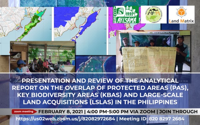
The Pambansang Kilusan ng mga Samahang Magsasaka (PAKISAMA), a national confederation of family farmers’ organizations, presented the analysis on the overlap of PAs, KBAs, and LSLAs during an online peer review on February 8, 2021. PAKISAMA hosts the National Land Observatory in the Philippines (NLO PH) and is a member of the Asian Farmers’ Association for Sustainable Rural Development (AFA), which serves as the regional focal point for the Land Matrix Initiative (LMI). The LMI is a global, independent, and open-access land monitoring initiative that promotes transparency and accountability in decisions over land investments by providing information, stimulating debate, and strengthening the position of stakeholders.
Mr. John Lagman, PAKISAMA Project Coordinator, highlighted that 58 out of the 175 LSLAs recorded in the Land Matrix database for the Philippines are located near or within KBAs and PAs, potentially impacting the environmental integrity of these areas, as well as the social and economic well-being of local communities and stakeholders. Particular case studies of interest include LSLAs in the island of Palawan, known as the “last frontier” of the country, which has a high density of endemic flora and fauna, as well as the case of the Kaliwa Dam in the province of Quezon, which serves as a source of water for its surrounding provinces, as well as the ancestral domain of several indigenous peoples’ (IPs) communities. Similar to the Kaliwa Dam, the case of Bugsuk and Pandanan islands in Palawan shows how LSLAs facilitate land grabbing of ancestral lands from indigenous groups.
Mr. Dave De Vera of the Philippine Association for Intercultural Development, Inc. (PAFID), which provided technical expertise in the development of the maps used in the report, emphasized that as part of our commitment to the Convention on Biological Diversity, it is our responsibility to ensure that all KBAs and PAs have legal protection by declaring them as parks and that they “shall be conserved… at all cost, otherwise, we will cease to exist as a country.” He further pointed out that in these KBAs, we have the watersheds that provide water, the remaining forests that capture carbon, the forests that provide resources for us. “When we overlay the existing land deals with these KBAs and PAs, we’ll understand whether we are truly living up to our commitment to the Convention”.
Discussions that followed produced some fruitful contributions, including how these overlaps stem from different factors. Atty. Christian Monsod, a member of the 1987 Constitutional Commission, for instance, shared that when granting permits for mining concessions, government agencies fail to consider the total economic value of the area or the natural resource. As such, the environmental externalities of such concessions are not covered. Organizing communities in these areas and providing them with the necessary tools, such as LSLA data and advocacy maps, which they can use to promote the protection of these KBAs and PAs as well as their rights to access and use land and natural resources in a sustainable manner, are also critical, Dr. Mary Racelis of the Ateneo de Manila University noted. She explained that not only do local stakeholders such as farmers, IPs, and women need help from NGOs and CSOs in understanding the issues and framing their own positions on this matter, but so too does society in general. For IP communities, in particular, such tools can be used in dialogues with government agencies, specifically the Department of Environment and Natural Resources (DENR) and the National Commission on Indigenous Peoples (NCIP), to promote the process of free, prior informed consent (FPIC). In terms of the policy, the group hopes that there will be an examination of the existing laws governing this issue to see what particular provisions can be passed to avoid these overlaps. These policies include the National Integrated Protected Areas System (NIPAS) law, relevant mining laws (e.g. Executive Order 79), and environmental impact assessment (EIA) laws, among others.
Dr. Ed Tadem of the University of the Philippines program on Alternative Development suggested that analysis of overlaps between LSLAs and ancestral domains, agrarian reform areas, and economic zones can be explored in the future. Lastly, Mr. Ward Anseeuw of the International Land Coalition (ILC), a member of the LMI, emphasized the importance of linking the insights gained from the analysis of LMI data to global frameworks such as the Sustainable Development Goals (SDGs), the Voluntary Guidelines on the Responsible Governance of Tenure (VGGT) and Responsible Agricultural Investments (RAIs).
PAKISAMA will be integrating these inputs in the finalization of the report this month.
To view the documents discussed in the online presentation, please follow the links below:
Infographics on the Kaliwa dam LSLA
Infographics on the Bugsuk LSLA
Comments are closed